1/8
가온 모바일 현장조사 시스템 (Mobile GPS) screenshot 0
가온 모바일 현장조사 시스템 (Mobile GPS) screenshot 1
가온 모바일 현장조사 시스템 (Mobile GPS) screenshot 2
가온 모바일 현장조사 시스템 (Mobile GPS) screenshot 3
가온 모바일 현장조사 시스템 (Mobile GPS) screenshot 4
가온 모바일 현장조사 시스템 (Mobile GPS) screenshot 5
가온 모바일 현장조사 시스템 (Mobile GPS) screenshot 6
가온 모바일 현장조사 시스템 (Mobile GPS) screenshot 7
가온 모바일 현장조사 시스템 (Mobile GPS) Icon

가온 모바일 현장조사 시스템 (Mobile GPS)

(주)나브컴
Trustable Ranking IconΈμπιστο
1K+Λήψεις
126MBΜέγεθος
Android Version Icon7.0+
Έκδοση Android
2.0.27(17-07-2021)Τελευταία έκδοση
-
(0 Αξιολογήσεις)
Age ratingPEGI-3
Λήψη
ΛεπτομέρειεςΑξιολογήσειςΕκδόσειςInfo
1/8

Περιγραφή του 가온 모바일 현장조사 시스템 (Mobile GPS)

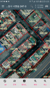
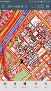
The best solution site survey map site survey heating system.

Field investigation !!! There is no longer the best solution.


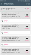
1. Use Naver, Daum, VWorld general maps and aerial photo maps in places that are not available on the Internet.

2. Save waypoint and save Excel, save as ESRI Shape file and send email

3. Unlimited track file storage and ESRI Shape file storage and email transmission

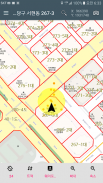
4. Supports the function of superimposing user drawings with aerial photographs

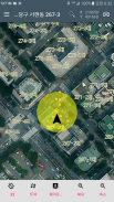
5. Check the site location through various searches

6. Supports various coordinate systems such as longitude and latitude, TM Jungbu origin, Dongbu origin, etc.

7. Immediately after taking a photo, save the photo file name as a place name


It can be used in the following tasks.

1. Forest field work

2. Investigation of pests

3. Published land price, individual house price survey

4. Cadastral-related surveying work (reference)

5. Mapping


We work with the following organizations:

Korea Forest Service National Agricultural Products Quality Management Service Ministry of Food, Agriculture, Forestry and Fisheries Korea Rural Community Corporation Korea Electric Power Corporation Cultural Heritage Administration

National Institute of Environmental Sciences Ministry of Environment Korea Land Information Corporation


Information on access rights

Storage space: Used to store and load data.

Location information (background): This app collects location data even when the app is closed or not in use, and enables features such as [GPS Log], [GPS Track], and [Current Location].


Privacy Policy: https://www.gaon123.co.kr/personal_policy/


가온 모바일 현장조사 시스템 (Mobile GPS) - Έκδοση 2.0.27

(17-07-2021)
Άλλες εκδόσεις
Τι νέο υπάρχει- 위치정보 동의 추가- 최신 모델에서 백그라운드 위치정보 허용 추가- QR코드 인식 추가- 산사태 야장 추가

Δεν υπάρχουν ακόμα κριτικές ή βαθμολογίες! Για να αφήσεις την πρώτη,

-
0 Reviews
5
4
3
2
1
Info Trust Icon
Εγγυημένα Καλή ΕφαρμογήΗ εφαρμογή αυτή πέρασε τη δοκιμή ασφάλειας για ιούς, malware και άλλες κακόβουλες επιθέσεις και δεν περιέχει απειλές.

가온 모바일 현장조사 시스템 (Mobile GPS) - Πληροφορίες APK

Έκδοση APK: 2.0.27Πακέτο: kr.co.navcom.gaon
Συμβατότητα Android: 7.0+ (Nougat)
Προγραμματιστής:(주)나브컴Πολιτική Απορρήτου:http://navcom.synology.me/wordpress/2017/02/10/%EA%B0%9C%EC%9D%B8%EC%A0%95%EB%B3%B4%EC%B2%98%EB%A6%AC%EB%B0%A9%EC%B9%A82017-02-10Δικαιώματα:12
Όνομα: 가온 모바일 현장조사 시스템 (Mobile GPS)Μέγεθος: 126 MBΛήψεις: 10Έκδοση : 2.0.27Ημερομηνία Κυκλοφορίας: 2022-12-18 03:23:32Ελάχιστη Οθόνη: SMALLΥποστηριζόμενα CPU: armeabi-v7a, arm64-v8a
Αναγνωριστικό Πακέτου: kr.co.navcom.gaonΥπογραφή SHA1: 4C:89:60:8A:7A:37:BC:C2:BA:99:A2:AD:54:CB:29:B8:CF:84:DF:7EΠρογραμματιστής (CN): Jason OhΟργανισμός (O): Navcom Co.Τοποθεσία (L): Χώρα (C): Πολιτεία/Πόλη (ST):

Τελευταία έκδοση του 가온 모바일 현장조사 시스템 (Mobile GPS)

2.0.27Trust Icon Versions
17/7/2021
10 λήψεις126 MB Μέγεθος
Λήψη

Άλλες εκδόσεις

2.0.16Trust Icon Versions
24/4/2021
10 λήψεις215 MB Μέγεθος
Λήψη
2.0.15Trust Icon Versions
8/4/2021
10 λήψεις122.5 MB Μέγεθος
Λήψη
2.0.14Trust Icon Versions
14/3/2021
10 λήψεις122.5 MB Μέγεθος
Λήψη
1.14.5Trust Icon Versions
9/3/2020
10 λήψεις57 MB Μέγεθος
Λήψη
1.4.6Trust Icon Versions
12/8/2017
10 λήψεις33 MB Μέγεθος
Λήψη

Εφαρμογές στην ίδια κατηγορία

Μπορεί επίσης να σου αρέσουν...